From The Rapidian staff*: From the beginning, story mapping has been a key component of The Rapidian. With that in mind we built the site so that it would be easy for reporters to enter geographical information into their stories and events whenever it makes sense.
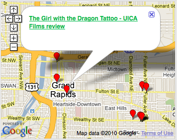
Having this information helps us visualize where stories are happening, geographically. This is interesting for a few reasons, not the least of which is that it helps us put stories into proper context. In a community that is as large, diverse, and (quite frankly) as geographically segregated as Grand Rapids can be, knowing where a story takes places helps us celebrate our similarities and differences. It can help us understand that the same issues that affect our own neighborhoods are affecting those in other parts of the city as well.
Maps are a powerful tool for understanding our community.
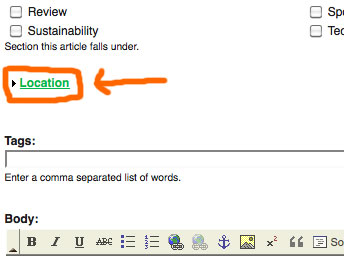
Geotagging (adding location information) your Rapidian stories is actually very easy to do, but also very easy to forget. To add an address to a story, simply click on the “Location” link between the list of article sections and the tags:
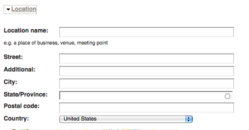
Clicking that link will pop open a form with fields like address, city, state, etc. Like so:
You simply fill that form out and the article or event will be geotagged when you press save. It's as easy as that!
Did you know that Flickr has a pretty robust mapping function too? You can see a map of all the images that have been added to
The Rapidian Flickr pool with geographical information by
clicking here.
Out of the nearly 3,000 images that have been added to The Rapidian Flickr group so far, only 150 of them have been geotagged.
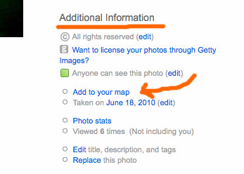
You can add geographical information to your own Flickr images by clicking the “Add to your map” link in the lower right hand corner of the Flickr image page. It’s under the heading “Additional Information:”
This adds a point on both your own Flickr map, but also The Rapidian group Flickr map I linked to above.
So far, the stories are only mapped on the front page of The Rapidian and in each of the quadrant pages.
But, there are a few new features planned in the not too distant future that will expand on our mapping capabilities and make the addition of geographical information in articles and Flickr images that much more important. It’s exciting.
You can help by getting into the habit of adding this type of information now.
Happy mapping!
Each week, a Rapidian staffer will publish a piece related to goings-on at The Rapidian, developments in the world of citizen journalism and tips for making the most of the site.
The Rapidian, a program of the 501(c)3 nonprofit Community Media Center, relies on the community’s support to help cover the cost of training reporters and publishing content.
We need your help.
If each of our readers and content creators who values this community platform help support its creation and maintenance, The Rapidian can continue to educate and facilitate a conversation around issues for years to come.
Please support The Rapidian and make a contribution today.